The goal of the project is to develop a tool for the analysis, conservation and management of landscape resources adequate to the territories subjected to a long period of human action that has influenced the characteristics of the landscape, in its environmental, economic and social components. The Historical and Cultural Evaluation Approach (HCEA), does not have the goal to detect or prosecute a socio-economic or an ecological balance, but to highlight the landscape features that define the cultural identity of a specific territory. Nevertheless, the method is particularly suitable for long-term environmental monitoring and for the assessment of issues such as biodiversity at landscape scale, that today is not yet subject to evaluation.
This method plans to analyze the landscape in a specific study area at different times, in order to reconstruct the historical landscape and to compare it with the current one. The result is the possibility to analyze the transformations that have taken place during this period, identifying the characteristics of typicity and significance and the main causes of vulnerability of the considered landscape.
The landscape in a specific area can be considered as a mosaic composed of contiguous patches, each characterized by a different land use. The land use then becomes the basic element of the landscape, which is then described and evaluated according to the characteristics of both the overall and the internal structure of that mosaic. Being heavily influenced by human activities, these landscapes, which are typical in Italy, to analyze as closely as possible the cropping systems, the texture of the mosaic and the changes, it is necessary to carry our an analysis with a high level of detail, that is able to identify the largest number of land uses.
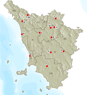
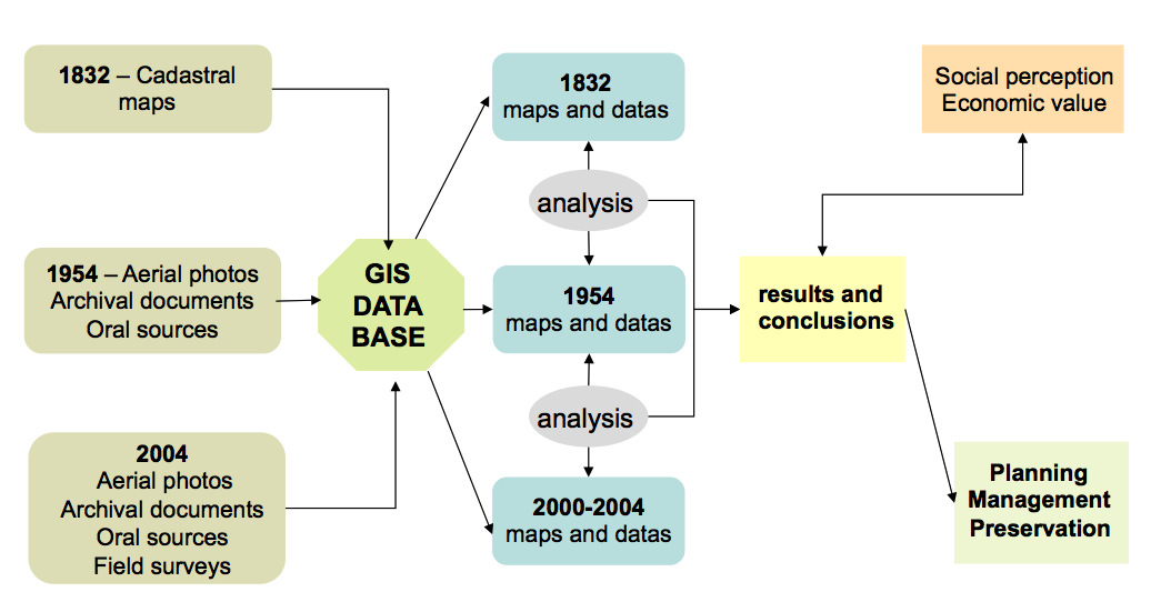
The multitemporal analysis applied for the monitoring of the Tuscan rural landscape, examines the changes that have occurred in the past 170 years in 12 study areas. The dates that have been chosen are: 1832, 1954 and the current situation. 1832 is the date of publication of the Leopoldino Cadastre, a rich and very detailed document that provides information on the structure of the land, and an essential testimony of the traditional landscape based on sharecropping. 1954 is the date of an airplane flight across the country, which provided the last image of the Italian countryside before the great agricultural transformations that have taken place since the Second World War. For some study areas, for specific reasons or for lack of photographic material, the date of 1954 has been replaced by another one. For the present landscape were used color orthophotos and field surveys. All the informations were processed using GIS software.
The study areas
1 – Moscheta
2 – Gargonza
3 – Spannocchia
4 – Barbialla
6 – Montepaldi
7 – Paganico
8 – Cardoso
9 – Migliarino
10 – Castiglione Garfagnana
11 – Mensola
12 – Firenze
 Diagram of the applied methodology


