1. Sila plateaus
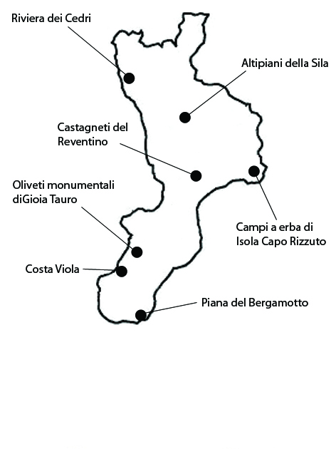
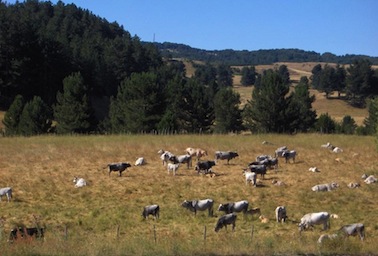
This is a silvopastoral landscape extending over 958 ha, constituted of woods interspersed with campi ad erba (grassy fields), in the municipalities of Spezzano della Sila, Spezzano Piccolo, Pedace, Serra Pedace. The area derives its significance from the historical importance of the Sila range, already described by Roman authors as an area of extensive woods with imposing trees. With progressive colonization and deforestation, often employing fire, these gradually gave way to pastures, giving rise to a silvopastoral system characterized by transhumance that lived on for centuries. The most widespread breed of bovine is the Podolica, a direct descendant of the aurochs, from whose milk the POD-branded Caciocavallo Silano cheese is produced today. Tree species include beech (Fagus sylvatica), larch pine (Pinus nigra calabrica), loricate pine (Pinus leucodermis). Shrubs include hemispheric juniper (Juniperus hemisphaerica) and herbaceous plants, some unique to Calabria such as Alchemella australica, Soldanella calabrella and Lereschia thomasii. The area shows a good degree of integrity. As regards vulnerability, over the last 50 years diminished anthropic pressure, a result of the migratory flows of the 1960s and 70s, has made its effects felt. The consequent expansion of woodland and concomitant shrinking of arable land and fields as they are progressively abandoned tend to reduce pastures, a trend that is strong today all over the Italian mountains. This process has a negative side-effect on landscape diversity, which is giving way to compact and homogeneous woodland, with a consequence reduction of biodiversity as regards species that thrive in non-wooded habitats. Another cause of vulnerability is tourist flows to the Moccone ski station and unregulated summer tourism.
2. The grass fields of Isola Capo Rizzuto
The landscape of this area, which extends over 1247 ha in the municipality of Isola Capo Rizzuto, is dominated by typical campi ad erba (grass fields). The area owes its significance to the role of grass fields in the Calabrian landscape and their historical persistence. With the rise of the latifundium system (1861- 1951), the landscape acquired an identity and an integrity that have remained unaltered until the present day. The local agricultural system was based on a six-year cycle: bare or green fallow, wheat, stubble field, and a resting period of three pasture years. This system had several purposes: restoring fertility by allowing land to rest, taking advantage of fallow periods to weed the fields, being present on the market with several different products (grain, milk, cheese, wool, meat), and controlling the labor supply by giving out terrageria (annual rent paid in kind) contracts for the stubble field period. In spite of deep social changes, the landscape has maintained its integrity. Historical continuity is observable in the property boundary system and in the still deserted vast inland areas between the plains and the mountains, originally left unsettled as a protection against raiding. Boundaries between properties, when they are not natural (ditches, rivers, ravines), are marked by a meter-wide strip covered with scinari, i.e., hedges of spontaneous shrubs with a prevalence of evergreen pistaches (called scinu in the Calabrian dialect), which allowed grazing livestock to roam freely after the wheat harvest. As regards vulnerability, this landscape appears threatened both by natural and anthropic factors. The latter include intensive cultivations, wind turbines, and especially uncontrolled building. The main natural risk factor, instead, is the widespread presence of blue clays that are resistant to plant colonization.
3. Reventino chestnut groves
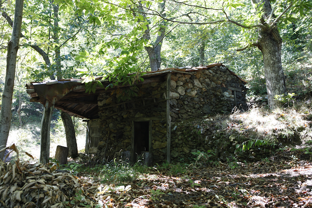
This is a wooded area with a prevalence of chestnut groves extending over 1465 ha within the municipalities of Cicala, Serrastretta, Gimigliano, San Pietro Apostolo, Carlopoli. The area owes its significance to the historical importance of the cultivation of chestnut tree, one of the forest species with the highest cultural importance in the Italian rural landscape. The chestnuts of Calabria are recognized as Traditional Food Products by the Ministry of Agricultural Alimentary and Forest Politics. A characteristic local landscape feature are large and small rocks projecting from the slopes of mountains, commonly known as pietre or timpe. There are many scattered farmhouses, some still operative, others in ruins, as well as old rural buildings made with an intriguing building technique employing small flakes of stone (mostly schist) bound with mortar. The integrity of this landscape has been compromised by reforestation with non-autochthonous species, and partly abandoned and partly coppiced chestnut groves. The emigration of about 65% of the population in the sixties resulted in a drop in chestnut production, which has recovered, however, in the last decade. The phytosanitary condition of the chestnut groves today appears to be good. This landscape system has many vulnerability factors. There is the phenomenon of abandonment and the gradual conversion of pure chestnut groves into mixed woods. Forest improvement actions often involve the felling of gigantic specimens. From a sanitary point of view, there is the risk of a resurgence of the ink disease, which has already been reported in other adjacent chestnut woods, and the setting in of new virulent strains of cortical cancer. Inadequate management of soil protection structures is another risk factor that should not be underestimated.
4. Violet Coast
This terraced landscape extending along the Tyrrhenian coast of southern Calabria, between Capo Barbi and Cannitello, with a total surface of 764 hectares lying within the municipalities of Palmi, Seminara and Bagnara Calabra. The area owes its significance to the historical persistence of a hilly landscape shaped by man over centuries to allow the growing of olive, citrus, mulberry, fig, vegetables and, above all, grapevine. The terraces alternate with small woods and open pastures. The terraces, known as rasule, are supported by dry-stone walls (armacie). The traditional vineyards are of pergola type, although today the espalier system is also used. The rasule extend for several thousand linear kilometers. Their depths range from barely a meter in some points to more than ten in others. They are supported by dry-stone walls with average thicknesses of half a meter and up to three meters high. Small stone staircases connect terraces at different levels. The small and middle-sized rocks are locally extracted. The walls are skillfully built by the farmers themselves or, more frequently, by specialized masons. They ensure drainage as well as the stability of the terrace. The Costa Viola landscape still retains a fair degree of integrity, although the total still habitually cultivated surface has decreased considerably since the early 1900s. Part of the merit for the conservation of the historical terraces rests with recently formed cooperatives of wine-growers and a few businesses that have managed to revive wine production, partially by introducing new grape varieties (Chardonnay, Cabernet, Sangiovese and Sauvignon) and modern transportation systems such as monorails. The area’s vulnerability is mainly a consequence of abandonment. The agricultural population is aging and/or migrating away from the area. The cost of labor has increased, property fragmentation is high, and the terraced cultivations are very hard to access and manage. The interruption of regular maintenance of the terraces, walls and drains, especially after traumatic events such as floods and earthquakes – not infrequent in the area – is increasing erosion and hence hydrogeological risk.
5. Monumental olive trees at Gioia Tauro
This monumental olive tree area extends over about 2434 ha in the municipalities of Gioia Tauro, Rizziconi, Taurianova. The area owes its significance to the monumental character and extension of its olive orchards, as well as their prominence in the landscape. Olive-tree growing appears to have been already well established by the Roman period as an element of the villa system of agriculture, and continued in the following centuries. In the seventeenth century it apparently was the only constantly expanding economic activity in the area. Pruning was an unknown practice, which accounts for the monumental size of the trees, under which citrus are often cultivated. Today olive growing is still the main feature of the local landscape ensuring a good degree of integrity. The area is dominated by monumental olive trees, including some 300 to 400-year-old specimens, and has an almost totally homogeneous appearance, its rather low urbanization rate having allowed it to preserve its traditional structure. As regards vulnerability, the expansion of urbanization poses little threat, except in the town of Gioia Tauro itself. A recent phenomenon is the uprooting of century-old trees which are then sold to be replanted in private properties and villas, often in the north of Italy. Other threats include unemployment, the underground economy, dependence on state subsidies, and organized crime, which intercepts financial flows destined for the transformation industry. A further element of vulnerability is the introduction of new crops such as kiwi.
6. Bergamot plain
This area is representative of the typical landscape of bergamot cultivation. It has an extension of about 1082 ha, within the municipalities of Brancaleone, Bruzzano Zeffirio and Staiti. The area is significant for several reasons, including the fact that it has the only bergamot cultivations in the world. The bergamot is a tree that grows to a height of 3 to 4 meters. The flowers are white and have an intense scent. According to some legends, the bergamot was imported by Christopher Columbus from the Canary islands. Other sources indicate China, Greece, or the city of Berga in Spain as its place of origin. The most plausible etymology is begarmundi, a Turkish word meaning “lord’s pear tree”. Bergamot essence owes its popularity to the Italian Gian Paolo Feminis, who, having emigrated to Cologne in 1860, created the formula for aqua admirabilis, combining other essences with the oil, manually extracted by pressing the skin of the fruit and absorbing it with natural sponges placed in containers. Eau-de-Cologne, so widely employed today, is based on that very recipe. Ever since, bergamot has remained one of the essential ingredients of this perfume. The present landscape is the result of a rather fragmented cultivation system, considering that almost 90% of the plots have an area between 0.5 and 5 ha. Although this is an old traditional cultivation, many of the orchards were planted in the early 1960s under the spur of favorable market conditions. As regards vulnerability, the ancient cultural tradition of bergamot cultivation experienced a first crisis in the early decades of the twentieth century, determined by the international marketing of synthetic perfumes. Poor production management, the lack of initiatives to protect the resource – although it has been classified as a PDO since 1931 and it is mentioned in the “Ark of Taste” list by Slow Food – and an inefficient commercial organization are the causes of the objective weakness of bergamot cultivation. One should also take account of the hydrogeological risk posed by the fiumare in this area, which sometimes also threaten human settlements.
7. The Riviera dei Cedri
This coastal citron-grove landscape extends along the Tyrrhenian coast in the municipalities of Santa Maria del Cedro, Scalea, Orsomarso, Santa Domenica Talao, for a total surface of 635 hectares. The Riviera dei Cedri is a highly significant landscape, not only because of the uniqueness of its typical crop, but also for its remote historical origins. Citron was the first citrus fruit grown outside its area of origin. Known in Iran ever since the seventh century BC, it was introduced to Greece by Alexander the Great in the fourth century BC. The Jews became acquainted with citrons during the Babylonian captivity (585-539 BC). From 136 BC onward, they started to employ them in the Festival of Tabernacles. After the diaspora they disseminated it throughout the Mediterranean, including Calabria, although it had already arrived here previously with the Greeks. The Riviera dei Cedri today is the only citron-growing area in Italy. To cope with harsh winters, these farmers turned their plots into ingenuously designed gardens with long rows of vertical poles planted next to the plants, and horizontal poles on which to train the branches to form a pergola, to which a roofing of cane or heather mats (cannizzelli) was added in the winter months. Although citron growing is much reduced today, in some zones the landscape still retains a fair degree of integrity. Although some areas still retain their traditional citron-grove landscape, there are several factors of vulnerability. In the first place, the demand for citron is declining sharply. Production has gone down from 7000 q of late ‘30s to ca. 3500 today. The period of worst crisis was in the 1970s. In 2010 two big cultivations of citron have been built, wide greenhouses covered with photovoltaic panels, that have a strong and negative aesthetic impact on the local landscape.


